


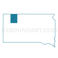
VTD-precinct 5, Perkins County, South Dakota
About
Outline

Summary
| Unique Area Identifier | 667722 |
| Name | VTD-precinct 5 |
| County | Perkins County |
| State | South Dakota |
| Area (square miles) | 269.72 |
| Land Area (square miles) | 260.49 |
| Water Area (square miles) | 9.23 |
| % of Land Area | 96.58 |
| % of Water Area | 3.42 |
| Latitude of the Internal Point | 45.78944320 |
| Longtitude of the Internal Point | -102.14563270 |
Maps


Graphs
Select a template below for downloading or customizing gragh for VTD-precinct 5, Perkins County, South Dakota


Neighbors
Neighoring Voting District (by Name) Neighboring Voting District on the Map
- Adams 39-01 Voting District, Adams County, ND
- VTD - Lemmon ward 1 (part of precinct 1), Perkins County, SD
- VTD - Lemmon ward 2 (part of precinct 3), Perkins County, SD
- VTD - Lemmon ward 3 (part of precinct 3), Perkins County, SD
- VTD - Lemmon ward 4 (part of precinct 1), Perkins County, SD
- VTD - precinct 12, Perkins County, SD
- VTD - precinct 6, Perkins County, SD
- VTD-precinct 3, Perkins County, SD
- VTD-precinct 4, Perkins County, SD
- VTD-precinct Grand Valley, Corson County, SD
- VTD-precinct Morristown, Corson County, SD
Top 10 Neighboring County Subdivision (by Population) Neighboring County Subdivision on the Map
- Lemmon city, Perkins County, SD (1,227)
- West Corson UT, Corson County, SD (306)
- Lincoln township, Perkins County, SD (164)
- East Adams UT, Adams County, ND (161)
- Northeast Perkins UT, Perkins County, SD (101)
- Lemmon UT, Corson County, SD (57)
- De Witt township, Perkins County, SD (42)
- Rolling Green township, Corson County, SD (30)
- Marshfield township, Perkins County, SD (30)
- Burdick township, Perkins County, SD (23)
Top 10 Neighboring Place (by Population) Neighboring Place on the Map
Top 10 Neighboring Unified School District (by Population) Neighboring Unified School District on the Map
- Lemmon School District 52-4, SD (2,124)
- Hettinger Public School District 13, ND (2,071)
- Bison School District 52-1, SD (912)
Top 10 Neighboring State Legislative District Lower Chamber (by Population) Neighboring State Legislative District Lower Chamber on the Map
Top 10 Neighboring State Legislative District Upper Chamber (by Population) Neighboring State Legislative District Upper Chamber on the Map
Top 10 Neighboring 111th Congressional District (by Population) Neighboring 111th Congressional District on the Map
Top 10 Neighboring Census Tract (by Population) Neighboring Census Tract on the Map
- Census Tract 9683, Perkins County, SD (2,982)
- Census Tract 9656, Adams County, ND (2,343)
- Census Tract 9410, Corson County, SD (1,744)